Sea Distance Calculator
Pick two ports or enter coordinates to get the distance in nautical miles, kilometres and miles, with optional via points for straits, canals and capes.
This sea distance calculator measures the distance between two ports, or two latitude and longitude points, in nautical miles, kilometres and statute miles. It uses the great-circle formula, which gives the shortest path over the Earth’s surface. You can add up to eight via points, such as the Suez Canal, the Panama Canal or Cape Horn, so the total follows the route you plan instead of a straight line that may cross land.
The list holds 57 major ports and 19 straits, canals and capes. For any other place, choose custom coordinates. The tool is free, runs in your browser, and nothing you type is uploaded. It shows each leg with its distance and initial bearing, and an optional speed gives the travel time.
How to use the sea distance calculator
- Open From (port) and pick the start port, or choose “Custom coordinates” and enter its latitude and longitude in decimal degrees (north and east are positive).
- Open To (port) and pick the destination in the same way.
- Under Via points, pick the straits, canals, capes or ports the route passes, in order. Use “Add a via point” for more, up to eight. Leave “No via point” for a direct line.
- Open More options and enter a Ship speed for travel time (knots) if you also want the travel time.
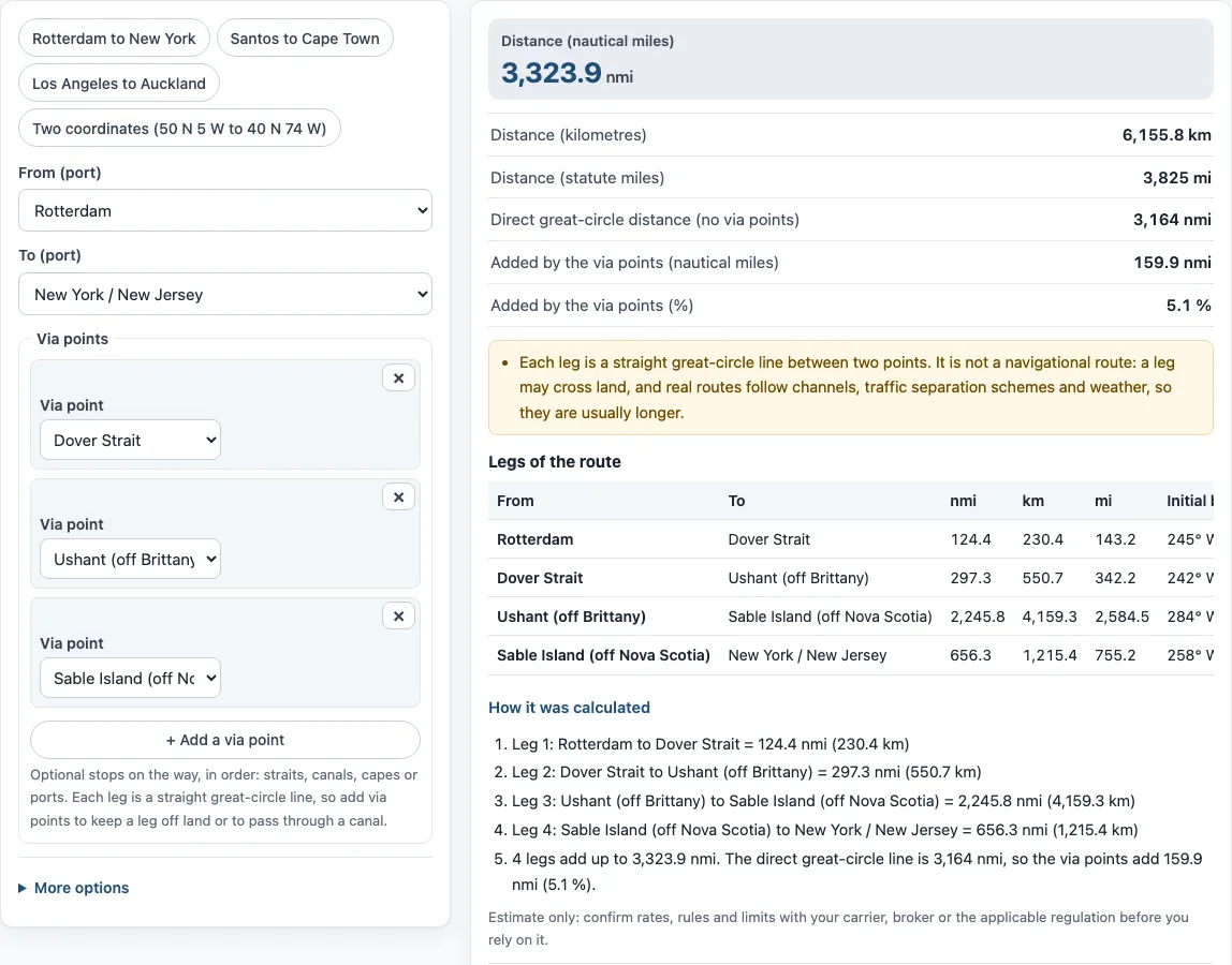
- Read the large Distance (nautical miles), then the kilometres and statute miles under it. With via points, the page also shows the direct great-circle distance and how much the via points add.
- Look at the Legs of the route table for each leg and its initial bearing, and How it was calculated for the steps. Check that no leg would cross land; if one does, add a via point.
Try the presets “Rotterdam to New York”, “Santos to Cape Town”, “Los Angeles to Auckland” or “Two coordinates”. Copy link shares your route, Print / save result prints it with the date, and Reset clears it.
How is the distance between two ports calculated?
The tool applies the haversine formula to the latitude and longitude of the two points and multiplies the angle by the Earth’s mean radius, 6,371.0088 km. It then divides by 1.852 to get nautical miles, because one international nautical mile is exactly 1.852 km. For example, 1 degree of latitude along a meridian is 60.04 nautical miles, and a quarter of the equator is 5,403.6 nautical miles.
The sphere is an approximation of the Earth, which is slightly flattened, so results can differ from an ellipsoidal calculation by up to about 0.5 %.
How do I calculate nautical miles between two coordinates?
Choose “Custom coordinates” for both From and To, then enter each latitude and longitude in decimal degrees. Use negative numbers for south and west. The “Two coordinates” preset uses 50 N 5 W and 40 N 74 W, and the result is the great-circle distance in nautical miles, with kilometres and statute miles below it.
Why is the sea route longer than the great-circle distance?
A great-circle line is the shortest path on a sphere, but ships cannot cross land. They pass through straits and canals, follow traffic lanes and avoid bad weather. Adding via points shows the effect. Rotterdam to New York is 3,164 nautical miles in a straight line, but that line would cross England, Ireland and Nova Scotia. With the Dover Strait, Ushant and Sable Island as via points the total is 3,324 nautical miles, which adds about 5 %.
Charted route distances, such as those in port-to-port tables, are normally longer again, so treat this figure as a planning estimate.
How do I add the Suez Canal, Panama Canal or Cape Horn?
Add them as via points in the order the ship passes them. For the Suez Canal use “Port Said” and “Suez (south end of the canal)”. For the Panama Canal use “Colon” and “Balboa”, and add a point such as “Straits of Florida” before Colon if the leg from a US East Coast port would otherwise pass over land. Cape Horn and the Cape of Good Hope are also in the list. The “Rotterdam to New York” preset shows a chain of via points.
How long does it take to sail a sea distance?
Divide the distance in nautical miles by the speed in knots to get hours. Enter a ship speed under More options and the page does it for you. At 21 knots, a 3,324 nautical mile passage takes about 158.3 hours, or 6 days 14 hours 17 minutes. For more detail, use the boat travel time calculator.
Where do the port coordinates come from?
Each port uses the coordinates that Wikipedia gives for its port, harbour or city article, rounded to four decimals. That is a point in the port area, not a berth. The via points use the coordinates of the strait, cape or canal end from the same source, except the “Strait of Malacca (mid-strait)” point, which is our own open-water position between the Sumatra and Malay Peninsula coasts.
Sources
Method and data (checked October 2026):
- Nautical mile, Wikipedia: the international nautical mile is exactly 1,852 m
- Haversine formula, Movable Type Scripts: distance and initial bearing formulas on a sphere
- Earth radius, Wikipedia: mean radius 6,371.0088 km (IUGG R1)
- Container ship, Wikipedia: economical voyage speed of about 21 knots
- Wikipedia articles for each port, strait, canal and cape: latitude and longitude of the point
Frequently asked questions
What is a nautical mile?
A nautical mile is a unit of distance used at sea and in the air. The international nautical mile is exactly 1,852 m, or 1.852 km, which is about 1.1508 statute miles. It was originally one minute of latitude.
Is this the real shipping distance between ports?
No. It is a great-circle distance, possibly with your via points. Real shipping routes follow channels, traffic separation schemes and weather, so they are usually somewhat longer. Use the figure for planning, and take binding distances from your carrier or an official table.
Can a leg cross land?
Yes. Each leg is a straight line on the globe and the tool has no map of coastlines. If a leg would cross land, add via points such as a strait or cape to keep it at sea. The page warns about this under the result.
How many nautical miles is it from New York to Rotterdam?
With the Dover Strait, Ushant and Sable Island as via points, the tool gives about 3,324 nautical miles, or 6,156 km. A straight great-circle line is shorter, at about 3,164 nautical miles, but it would cross England and Ireland.
Can I use coordinates instead of a port?
Yes. Choose “Custom coordinates” for From, To or both, then enter the latitude and longitude in decimal degrees between -90 and 90 for latitude and -180 and 180 for longitude.
Does the calculator include the Suez or Panama canal?
Only if you add them as via points. The tool has no routing engine, so it does not choose a canal for you.
Can I use the results in quotes and plans?
You may use the results in commercial work such as quotes, schedules and plans without attribution. They are estimates, so confirm distances with your carrier or an official source before you rely on them.
Related tools
- Boat travel time calculator: use it to turn a distance and speed into a travel time and ETA.
- Knots to mph converter: use it to convert speeds and nautical miles.
- Shipping container dimensions: use it to look up container sizes.
- Pallets in a container: use it to see how many pallets fit in a container.
- All logistics calculators: use it to browse every calculator on this site.